A workshop on Mouza- and plot-based National Digital Land Zoning was held in Mohanpur upazila of Rajshahi on Thursday, aiming to promote the planned use of land, protect agricultural land and help control unplanned urbanisation and industrialisation.
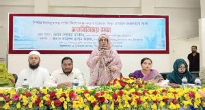
The workshop, titled “Awareness, Verification and Sensitisation on Mouza- and Plot-based National Digital Land Zoning”, was held at the conference room of Mohanpur Upazila Parishad at around 10am.
The event was organised by the Mouza and Plot-based National Digital Land Zoning Project under the Ministry of Land, with support from Mohanpur Upazila Administration.
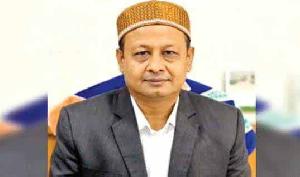
Additional Deputy Commissioner (Revenue) of Rajshahi Md Mohinul Hasan attended the programme as the chief guest, while Mohanpur Upazila Nirbahi Officer Fahima Binte Akhtar chaired the session.
Speakers discussed the need for land zoning, collection and verification of mouza- and plot-level digital data, classification of land according to use, and the importance of reliable land-use information for future land management.
They said land zoning is a government initiative aimed at classifying land into different use-based zones by taking into account its suitability, natural characteristics, environmental considerations and development needs.
The initiative is expected to help protect agricultural land while reducing problems arising from unplanned housing, industrial development and other forms of land use.
Md Rashed Sarwar, GIS and Remote Sensing Analyst of the project, and Md Mahbub Islam, Agriculture Specialist, gave presentations on various aspects of land zoning.
They explained how digital technologies can be used to collect and analyse land-use information, conduct field-level verification and classify land according to its appropriate use.
According to project officials, land under the zoning initiative is planned to be classified into 18 zones. These include agricultural, special agricultural, and agriculture-fisheries zones, as well as rivers, canals, water bodies, reservoirs and wetlands.
Forest and protected areas, environmentally critical or sensitive areas, hills and fallow land will also be identified separately under the zoning system.
The proposed classification also includes urban and rural residential areas, mixed-use areas, commercial and industrial zones, transport and communication areas, institutional and civic facilities, and cultural and heritage sites.
Speaking at the workshop, ADC (Revenue) Md Mohinul Hasan said accurate information was essential for effective and planned land management.
“Plot-based digital zoning can provide a data-driven framework showing how land is currently being used and what types of use may be suitable in different areas in the future,” he said.
He added that such a system could improve coordination in land management and make it easier to take effective measures to conserve agricultural land.
A number of government officials, academics, local representatives and civil society members attended the workshop, including Assistant Commissioner (Land) Zobaida Sultana, Mohanpur Police Station Officer-in-Charge Mizanur Rahman, Senior Fisheries Officer Md Aminul Islam, Livestock Officer Dr Khandaker Sagar Ahmed, Youth Development Officer Syed Ali Reza and Social Services Officer Imam Hasan Shamim. Mohanpur model pressclub secretory Md Shahin Sagor, Mohanpur pressclub president Rubel sarkar, secretory Rasel Sarkar, kendriopressclub secratory Muttakin alom sohel.
Representatives from agriculture, statistics, women and children affairs, primary education and other government departments also took part in the event.
Teachers and civil society representatives from Mohanpur Government College, representatives of local farmers, local government representatives and other stakeholders also participated.
The participants were briefed on the objectives and activities of the zoning project, with emphasis on local-level verification of information and raising public awareness about the initiative.
Experts said rapid urbanisation and development activities were putting increasing pressure on agricultural land and wetlands.
They observed that digital land zoning could play an important role in developing a more planned land management system by identifying land types and appropriate uses.
If implemented properly, they said, the initiative could help maintain a balance among agriculture, housing, industry, environmental protection and transport infrastructure.